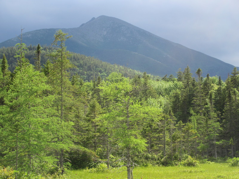
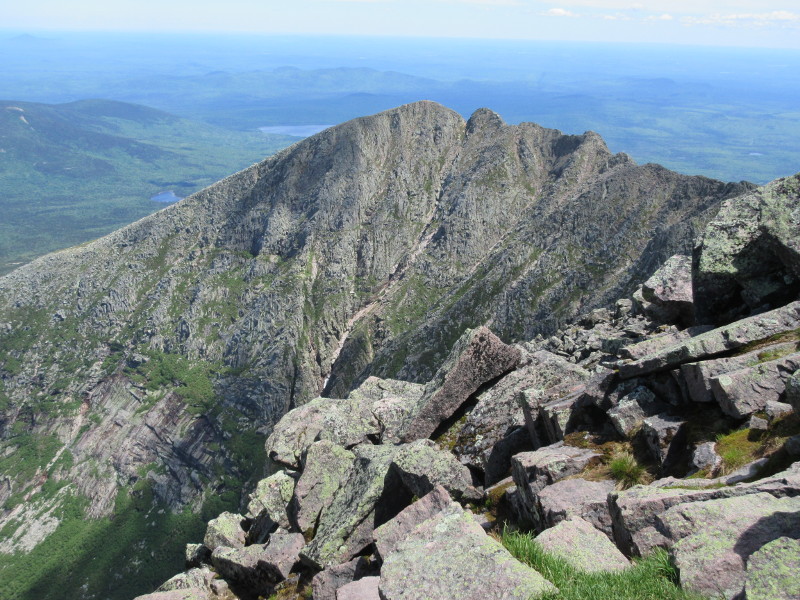
Pamola Peak from a Roaring Brook Nature Trail viewpoint.
Maine Highpoint - Mount Katahdin - 5267 ft
22 Jun 2017, 11:30 am. Highpoint #45.
In the morning on 21 Jun, Dave, John, Tom and I drove to Baxter State Park and Kahtadin. When we got to Millinocket, we turned left onto Central Street, drove to the Appalachian Trail Cafe, and stopped for lunch. The Cafe caters to the through hikers that finish the complete Appalachian Trail hike on the summit of Katahdin. The ceiling tiles are covered with autographs of completed through hikers, and there was another tile accessible, so that any completer could sign their trail name onto it, and when that filled up that tile would go into the ceiling. You are eligible if you complete the entire hike, but it can be in sections, you do not have to hike all of it at once. They also had plenty of souvenirs, both for the Appalachian Trail and for just Katahdin. My favorite were the t-shirts. We had a good lunch, although we all declined the through-hiker inspired dessert, which consisted of 14 scoops of ice cream (one for each state that the AT crosses), plus a donut and more sugary things. Only a genuine thru-hiker could safely eat that!
After lunch, we continued on to Baxter State Park. After passing the gate, we continued for 8 miles along Roaring Brook Road, on to Roaring Brook Campground, and our lean-to campsite, at an altitude of 1489 ft. The unpaved road was generally no problem for a passenger car, although a little care was needed when passing, and on occasional short steep sections.
When I planned this trip to Kahtadin, I chose mid-June as a good time of year, with good weather, and before the big crowds later in the season. What I did not consider, was the reason that the crowds did not arrive yet. Namely, the bugs. I was about to discover how horrible the north woods insects are in the early summer. When we were visiting Acadia National Park, the mosquitos were only a mild annoyance, but that respite ended at Baxter State Park. The moment we opened the car doors at the campground, we were hit by a mass mosquito assault.
The lean-to site was not ideal for insect defense, since the open face of the shelter did nothing to keep the bugs out. You are not supposed to use tents on the lean-to sites, but we decided that tents inside the shelter itself were ok. This way, we all had some kind of mosquito protection while we slept. The shelter could have used more attachment points for tying up netting though. Besides this, we all had plenty of DEET, and Tom and I both had a headnet, which we bought for our trip to the Upper Peninsula of Michigan. I insisted on them for that trip, where they were not necessary. But the nets were very welcome in Maine!
With camp set, we went for a short hike on the Roaring Brook Nature Trail. The trail crossed over Roaring Brook Creek on a bridge, followed the creek, entered the woods, and then came to some open viewpoints in a peat bog. We had views of pitcher plants up close, and Pamona Peak, with the Knife Edge barely visible, in the distance. The insect assault was sustained and continuous. Mostly it was mosquitoes, but black flies also welcomed us. The headnet was useful! We returned to camp, and prepared to battle the bugs there. The first order of business was to start a fire. With the fire going, we made dinner, then played some hackeysack (one rule: No apologies!) until daylight faded. The fire did deter the insects, but my head net was still plenty welcome. We stayed up late, and I suspect that our neighbors would have preferred that we turned in earlier. Oops.
Pamola Peak from a Roaring Brook Nature Trail viewpoint.
We woke up early the next morning, and were on our way by about 6 am. We signed into the register, and at the end of the campground, we started on the Chimney Pond Trail, and soon came to the turnoff onto the Helon Taylor Trail. We turned left onto this trail, and started the steady trudge up Pamola Peak. The ascent was a steady grind up a steep trail, with occasional minor scrambling. By about 8 am, we had some views back the way we had come.
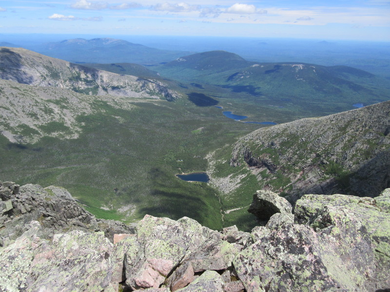
Views looking back as we ascend Pamola Peak in the morning, with Katahdin Lake to the right, and Sandy Stream Pond to the left.
A bit after 9 am, we came to the top of Pamola Peak, and got our first view of the Knife Edge and the exposure that we would enjoy. Stiff winds hit us right as we came to the top, which was a little nerve-wracking with the exposed terrain ahead. We took a short break on the summit of Pamola, and then started on the Knife Edge itself just before 9:30 am. The winds did free us from the mosquitos for a while. Once we had started moving in the morning, they quit being much of a problem, but coming up above the trees and into the wind meant that they stayed away. For a while.
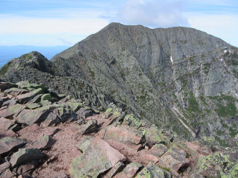
Our first good look at the Knife Edge ridge, from atop Pamola Peak. The summit is towards the right of the photo.
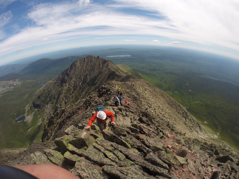
The first challenge, and the technically hardest one, was a downclimb into the Chimney, followed by an upclimb onto Chimney Peak and the main ridge. Several other hikers had joined us atop Pamola Peak, so there were some traffic jams on the Class 3 downclimb, as everybody waited for their turn. Soon enough we were all down, and then climbed up some Class 3 rock up Chimney Peak onto the main Knife Edge. My legs started to cramp up as we completed this section. I guess the hard work of climbing Pamola had caught up to me. This would have been a good time for some electrolyte tablets, but instead I made do by massaging my thigh muscles until I worked out the cramps. This was a satisfying place to reach. We had completed the hard parts: The physical work was mostly in climbing Pamola, the technically hardest part was traversing the Chimney, so all we had left was the exposure, which was just starting.
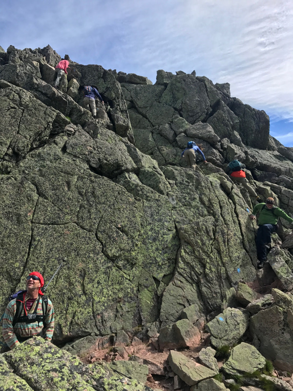
Descending the Chimney. Dave and John are already down, Tom and I are next, with other hikers behind us.
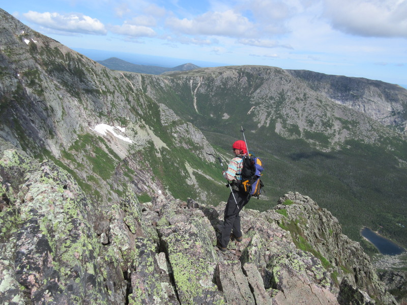
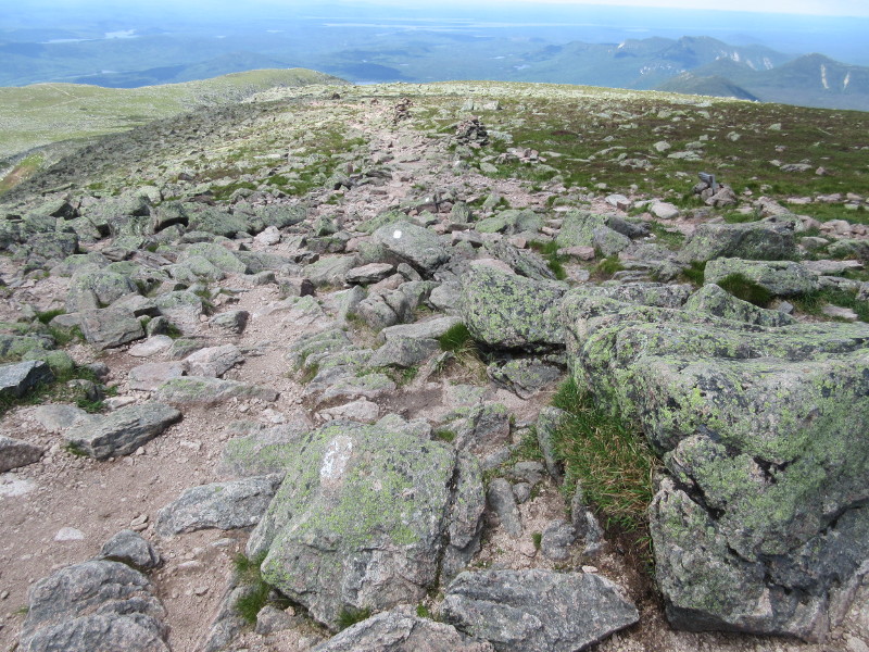
We then proceeded with the Class 2 hiking over the talus on the ridge. The ridge was exposed, with huge drop-offs to the left, and especially to the right into Great Basin, and it was never very wide. Although there were a few narrow spots, mostly the ridge was plenty wide so that the terrain felt comfortable, but with amazing views. The stiff winds added some excitement, so I tried to move carefully. The winds blew from left to right, so I usually stayed to the right off the crest to be out of it a bit. At one narrow point, this strategy had me on some quite exposed rocks with Great Basin far below me, so I made sure not to slip. There was not really any actual physical trail, but the path was well marked with blue blazes, and there was only one way to go anyways.
Dave looks down into Great Basin to take in all of the air below.
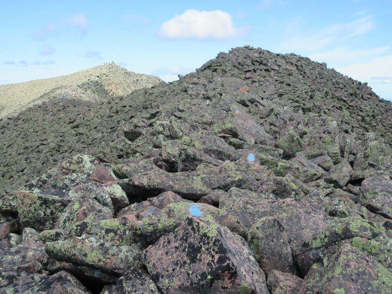
Blue blazes mark the path along the talus on the Knife Edge.
Scrambling up a steeper section of the Knife Edge.
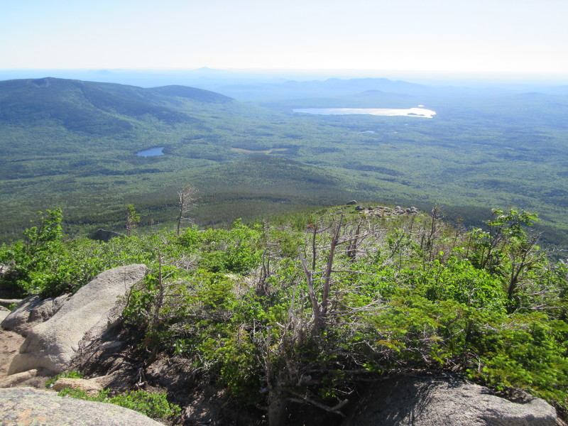
By 11 am, we were very close to the summit, and took a nice long break while we admired our goal. By this time, the wind had died down some, so this was a pleasant break, with incredible views. The view of Great Basin down to our right was spectacular. Ahead of us, to the left, was the shoulder of the mountain where the Appalachian Trail covers its final yards. Behind us we could see the Knife Edge from where we had come. Thousands of feet below, the land was covered in the deep green of the north woods. Then we packed up, and 15 minutes later, we came to the top of Katahdin.
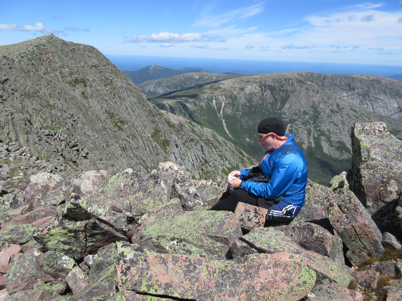
John enjoys a snack with the summit of Katahdin just ahead.
Several trails meet at the summit. Besides the Knife Edge/Helon Taylor trail that we had climbed, the summit is the famous northern terminus of the Appalachian Trail, which came in from our left. On our descent we would pass over the summit and descend the Saddle Trail. There was a sign noting the end of the Appalachian Trail, and a boulder next to it seemed to be the highest natural ground. So I stood on it and claimed Highpoint #45 at 11:30 am. The mountain itself is 13 feet short of one mile high, so somebody built a huge 13 foot tall cairn to reach exactly one mile above sea level, but that does not count as natural ground! It was fun to see the final white blaze of the Appalachian Trail. Our route crossed over the summit but did not otherwise follow this trail. I have hiked several small sections of this famous 2000+ mile trail, although nowhere near the full length, and my favorite section may now be this one, with a total length covered on the AT of zero. We spent about an hour at the summit, then started down just before 12:30 pm.
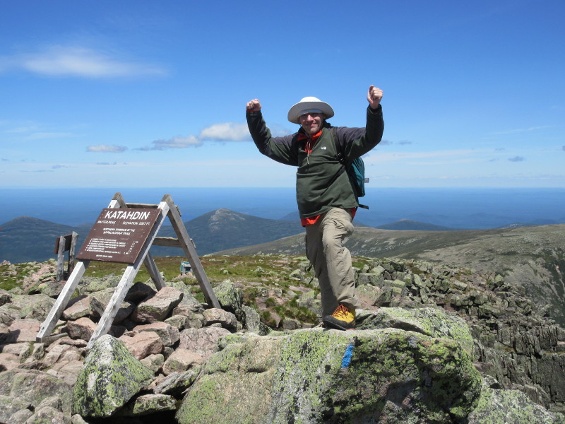
My 45th state highpoint!
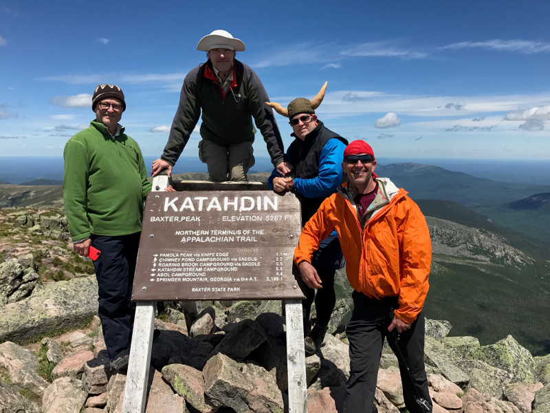
Tom, me, John, and Dave at the highest point in Maine, and the end of the Appalachian Trail. Note the mile-high silly hat!
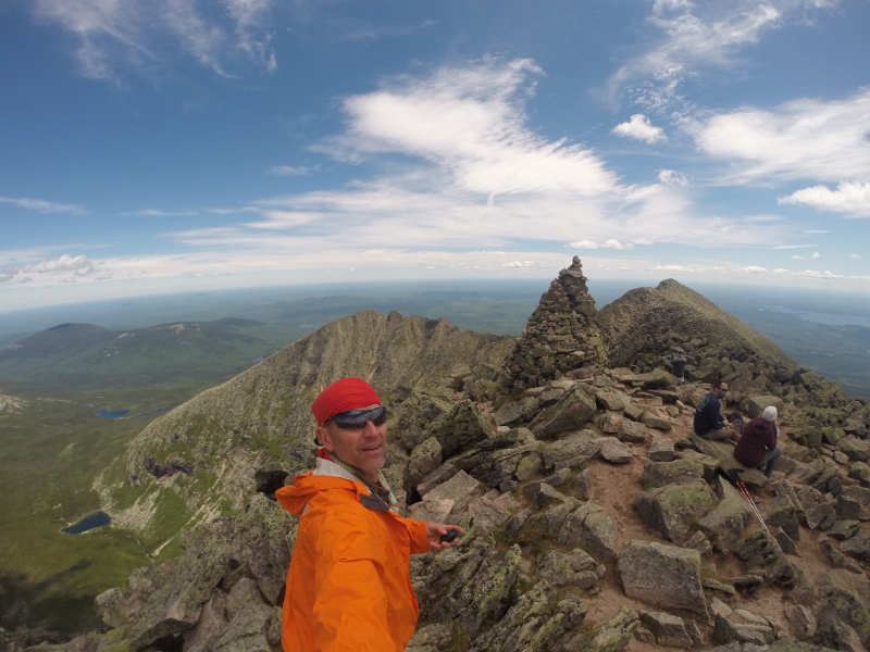
Dave takes a panorama showing the mile-high cairn atop Katahdin, with the Knife Edge and Pamola Peak behind.
The final white blazes of the Appalachian Trail. The Appalachian Trail is marked with white blazes, and other trails with blue blazes.
A look back at the route that we had ascended.
Spectacular view of Great Basin from the summit.
We started down the Saddle Trail, with the edge of Great Basin to our right. The trail descended at a steady clip, then came to a right turn to start the descent of the steep rim of Great Basin. From here, we could look back and see Pamola Peak, and our route, well above us. From here, the trail was loose and very steep, but dry, as it descended the steepest part of the rim. About 20 minutes later, we took a break, and were joined by a pretty green moth. There was still some of the steep descent left, but most of what remained was tedium.
The trail gradually flattened as it descended, so we got the worst of it over with first, but there was plenty of distance back to camp. As we descended below treeline, the insects, which I had almost forgot about, came back to harass us. This was tolerable as long as you kept moving, but if you stopped, even for a few seconds, a mosquito swarm would queue up. We let ourselves get separated on the descent, with Dave and John bounding ahead, followed by me, with Tom behind. The trail passed by Chimney Pond, and passed a couple of intersections as it became Chimney Pond Trail, and I was the only one with a map, so I wanted to wait for Tom and make sure he made the correct turns. Unfortunately, the mosquitos drove me off after 5 minutes or so, before Tom caught up, and he did indeed get to go the wrong way for a while. From Chimney Pond, there was a bit more than 3 miles left of tedious trail, which passed Basin Ponds on the way back to the campsite.
After returning to our campsite, we had the choice of lounging around in a mosquito cloud, or driving to a real restaurant for dinner. We chose to leave for dinner. We drove out of the park, then about 10 miles farther, then turned onto a gravel road for a mile or so, to a hotel and restaurant. We took a seat outside, and enjoyed a nice meal. All the waitresses had climbed Katahdin, which I thought was cool. We then returned to the park, and returned to our fire-making ways until it was time for bed.

A cool moth visited us as we rested on the descent.
References
Hiking Maine's Baxter State Park, Greg Westrich, Falcon Guides, 2017.
Katahdin Baxter State Park Trail Map, 2nd edition, Map Adventures.
Highpoint Adventures, Charlie and Diane Winger, Colorado Mountain Club Press, 2002.
Highpoints of the United States, Don W. Holmes, University of Utah Press, 2000.