
Mount Mansfield resident.
Vermont Highpoint - Mount Mansfield - 4395 ft
17 June 2005, 1:32 pm. Highpoint
#31.
Back to 2005 Northeast Highpoint Expedition
After a fine breakfast on 17 June, at the Blue Line Diner in Burlington, VT (across the street from the Motel 6), I drove east and followed the Winger directions to Mount Mansfield, in the grey fog and steady rain. I drove up the Stowe Toll Road, which is now $18 admission. Although unpaved, the road is mostly in very good shape. (It ought to be, for that price!) After driving to the top, I set out from the Visitor Center, near the 'Nose'. This trail is really neat. Mostly, it is on rock, which is this nifty green schist rock, marked with white blazes. Much of the rest of the trail was under water, as it had rained a lot lately, and was currently coming down pretty steadily. (No sign of any storms, however.) As I dodged water puddles and avoided slips on the wet rock, continuing north towards the summit, a series of peaks loomed out from the mist. They all looked like they might be the top, but they were false summits, with the true one obscured by the clouds. As I reached each intermediate peak, the next one became visible in the distance. The hike is not very long, so I soon reached the true summit, marked with a USGS marker, so I knew I had reached the highpoint. (There was no sign or anything else, however.)
Mount Mansfield resident.
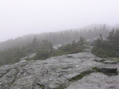
A typical vista on Mount Mansfield - A false summit looming through the fog,
over the white blazed green schist trail.

View from the summit.
I had originally planned a more challenging hike. I hoped to take the Long Trail from the north, which is about a 2800 ft elevation gain, and about twice as long a distance. I heard some advice that this trail is fairly precipitous and exposed, and might not be the best idea if it were slippery and wet. (The trail certainly would have been soaked.) In addition, my feet were a little worse for the wear from two damp days on Mount Washington, and another fairly long day in the rain didn't sound so appealing. So, I settled for the 'wimpier' hike along the Long Trail from the south. This worked out great, a couple of hours of walking through puddles was all I was really in the mood for anyways, and the trail from the south is neat. Hopefully, I'll be able to return sometime and take the harder route.
After the hike, I drove west towards Lake Placid, NY. On the way, I took the ferry from Burlington across Lake Champlain, which was kind of fun. I did not see my distant relative Champy (cousin of my closer relative Nessie), although there were newspaper articles posted in the ferry that described some 'sightings'. After a little over an hour on the water, the ship arrived at Port Kent, on the edge of the Adirondacks, and I drove on to Lake Placid. In the topical beer department, I found 'Long Trail Ale' in various places in New England. The same brewery also makes a 'Hit the Trail Ale'.
References
Highpoint Adventures, Charlie and Diane
Winger, Colorado Mountain Club Press, 2002.
Highpoints of the United States, Don W.
Holmes, University of Utah Press, 2000.
Mt. Mansfield Visitor's Guide - 'Free' with the $18 toll up the road