View below Lake Isabella.
2005 Utah Soccer Trip
(Click on the links for more detail about each highpoint, including pictures.)
31 Aug - I leave Austin, with a two day drive to Colorado as the first item on the agenda. Gas prices have risen sharply, due to the recent Hurricane Katrina, so I am happy to have my fairly efficient Honda Civic.
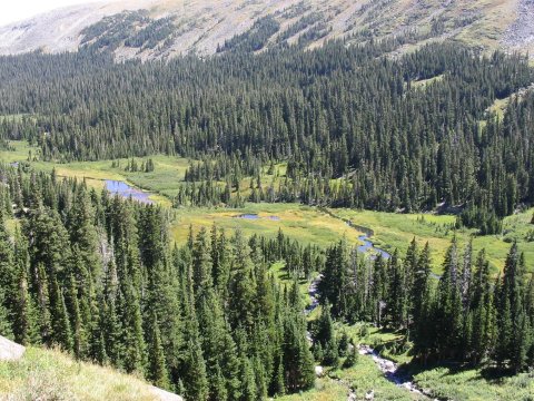
2 Sep - I think I have chosen the Brainard Lake area as my official first acclimatization stop for any trip into Colorado. After arriving from sea level, my body needs a taste of high altitude air, so it can start to adjust, before I set out on anything difficult. This area is easy to get to, the trail is easy and level but over 10,000 ft, and the setting is very pretty. It fits the bill perfectly. I drive south on CO 72, then just north of Ward (about 10 miles north of Nederland), I turn right (west) onto CR 102. I put on my daypack, and head west on the trail towards Lake Isabelle. This passes Long Lake along the way, and then on to Lake Isabella. I keep on going a little bit past Isabella, stop for a lunch break, and then return to the car.
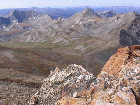
View below Lake Isabella.

Lake Isabella, with some of the Indian Peaks behind.
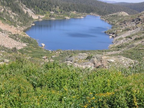
Looking down on Lake Isabella.
I'll be staying with my friend (and fellow highpointer) Jim Buckley, so I drive on to his house in Longmont. When I get there, I meet his friend Jason, his wife Allison, and their 11 month old son Jacob. I've already met Jim's wife Kristie, as well as Mongo, the Ground Guy. That evening, we all head out for a hearty Italian dinner, and then I try and get some sleep before my 4 am wakeup the next morning.
3 Sep - My alarm goes off at 4 am, but I am already awake, thanks to the Ground Guy, who is prodding me to get up. My pack is already ready, so I eat a little breakfast, and head out the door. I haven't got a key to the house yet, so I'll be stuck outside once I close the front door. Mongo tries to take advantage by running outside just before I shut the door, but I put him back inside. I do forget my map, though.
My plan for the day is to continue my acclimatization routine by climbing Mount Lady Washington, thus getting a fabulous view Longs Peak, the highpoint of Rocky Mountain National Park. I get to the Longs Peak trailhead by 5:15 am or so, and the parking lot is well past full, so I park down on the road, then set out on the trail in the darkness. The crowds are heading for Longs Peak, hardly anybody is going where I am. I make it to the top, get some pictures, then take the longer but easier way down.
That evening, after returning to Longmont, I turn to the TV and watch the USA defeat Mexico 2-0 to clinch a spot in the 2006 World Cup finals in Germany. http://fifaworldcup.yahoo.com/06/en/050904/1/4jg1.html

"The USA is a small team... They play like my sister, my aunt, and my
grandmother."
Mexico coach Ricardo La Volpe after losing 2-0.
4 Sep - I leave Longmont, and drive west, through Leadville, then onto Chaffee County 390 and to the Missouri Gulch trailhead. CR 390, a dirt road, is wide and, on a 1 meter scale, level. It does have lots of smaller 'washboard' ripples, however, which require me to slow down to very slow speeds to avoid rattling my car to bits. Once at the trailhead, I put on the overnight pack, and start up the steep, relentless, trail up Missouri Gulch. At around 11300 ft, the trail finally levels off, just before exiting the trees. Here, there is an old ruined cabin, and several campsites. I pick one, and set up my tent, with not too much light remaining. A stream near the campsites provides water, and after treating some I cook dinner in the darkness and then head to sleep. The next day, I hike south to Elkhead Pass, and look down into the pretty Missouri Basin. The whole area is very pretty, and it would probably be even better a little earlier in the year when it is more green, but it is still nice. There are lots of other people around, it is Labor Day and the weather is good, so the crowds are out.
The following morning, I head for Mount Belford. Just past the campsites, the trail leaves the trees and offers a nice view of Belford. I see two hunters here, armed with firearms, who are scanning the surroundings with binoculars. I'm kind of surprised to see hunters in a wilderness area, and everybody I talk to seems to think that it is not hunting season. There had been some snow the night before, and the upper parts of the surrounding peaks have a dusting of white on them. The weather is not clear, but rather cloudy with occasional rain which turns to intermittent sleet. As I am continuing up the trail, I wonder if the weather will force me back. Looking towards the west, where the clouds are coming from, the conditions don't look any worse, and it isn't storming, so I keep on. The cloudy, sleeting conditions continue as I ascend, but when I get about two thirds of the way up, I see some blue sky to the west, so it seems like things will improve. They do, and by the time I reach the 14197 foot summit, I am enjoying lovely blue skies and perfect conditions. There are views of 14000+ foot peaks all around me, and also a fabulous view into Missouri Basin, with the elegant 13er Emerald Peak behind. A few minutes after I reach the top, one other hiker joins me. He is the only other person I saw on the mountain all day, much less crowded than the day before. I decide I am not in the mood to make the hike over the connecting ridge to Mount Oxford, another 14er, so after a nice long break to take in the view, I return to my camp, take everything down, and hike back down the steep trail to the car, and drive back to Longmont.
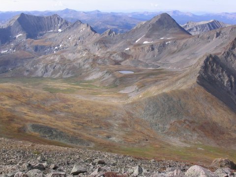
Missouri Basin, from high on Belford.
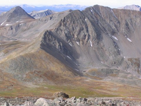
Emerald Peak and Missouri Mountain, also from high on Belford.
Looking down on Missouri Basin from the summit of Belford.

Looking back towards my camp and the trailhead, from the summit.
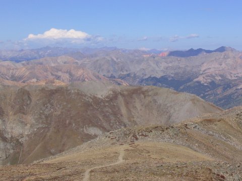
Views of peaks in all directions, from the top.
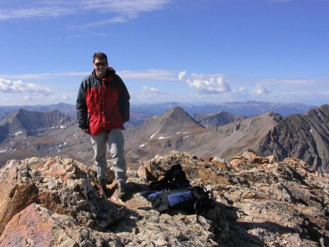
Me on the summit.
7 Sep - Today's goal is South Boulder Peak. Jim and I drive to Boulder, where we pick up Martin, and then head to the trailhead. I hadn't met Martin before, but I had stayed in his condo in Keystone before, while Jim, his brother Tom, and I hiked up Mount Elbert, the Colorado highpoint. Jim has a loaner convertible at the moment, and I am enjoying the ride, with the top down, and some cool new music playing. We stash three beers near the trailhead, hear a report of a mountain lion in the area, and start up the trail. The trail is steep and rocky, and Martin is setting a good pace, so I am getting a workout. We reach the summit, and take a long rest while we check out the view. Boulder is mostly hidden, but we have a clear view of Longs Peak. Eventually, it is time to go, and we head back to the trailhead and claim our beers. Both Jim and Martin have cars in the shop to pick up, and we hurry to beat the 6 pm closing times. At 6:01, we are just blocks from Martin's mechanic, but that is too late. Jim has better luck, and (sigh) returns the convertible. The only mountain lion we see is Mongo.
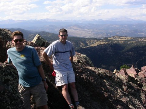
Me and Jim (l to r) atop South Boulder Peak.

Jim's pet
mountain lion, Mongo.
The Ground Guy made
sure that I got up and moving on time.
8 Sep - After a late breakfast at Janie's in Longmont, I say goodbye to Jim, Kristie and Mongo, and head towards the highpoint of Utah. I drive on to Rock Springs, WY, to a convenient Motel 6. On the way, I pass some trucks carrying white phosphorous. These trucks are more heavily protected than most chemical trucks, with an outer cage around the tank, since the cargo is so dangerous. I resist the urge to hijack them for an addition to my element collection. The next morning, I drive on to the trailhead to Kings Peak, and hike into the High Uintas Wilderness to try and get my 37th state highpoint. A strong storm gives me some excitement, but unfortunately also drops a lot of new snow. Two days later, when I reach the final ridge to the peak, I decide that the snow covered terrain is too treacherous, and I turn back, still stuck on 36.
When I return to the car from the Kings attempt, I drive on towards Salt Lake City, for the Texas - BYU soccer game. Utah has changed all the exit numbers, unknown to me, and I have a hard time finding a motel.
12 Sep - With the soccer game in the evening, in Provo, I have half a day to wander around downtown Salt Lake City. My burnt orange shirt attracts immediate attention from a passer-by, a Texas law school alum. The conversation turns to Texas football, and I catch my first report of the Ohio State game which I had missed while camped in the hills. I happen across an interesting used book store downtown, I forget the name. Besides lots of Mormon related books, which are not interesting to me, they have a lot of history books and a rare book room. I see a nice photo book of the Karakorum in Pakistan, signed by Ed Viesturs, the first American to climb all the 8000 meter peaks, but I don't buy it.
That evening, I drive south to Provo for the soccer game. Since I now know about the exit number changes, I find the stadium without problems. It is set right below some nice peaks, which make a pretty setting, besides looking like fun to hike. Unfortunately, BYU controls most of the game and hands the Longhorns a loss. Texas 0 - BYU 1 A fire at some apartments next to my motel that night creates some excitement, but nothing more.
13 Sep - The next morning, I start the long trip back to Austin by heading to Arches National Park, about a 4 hour drive from Salt Lake. I get there too late to get a campsite, but I get to see some neat stuff in the half day I spend there. After watching the sunset at Delicate Arch (which is not to be missed), I find a motel in Moab.
14 Sep - The next morning I continue southeast, with a stop at Mesa Verde National Park. I make the short, easy walk to the park highpoint, then make an equally brief stop to get some photos of the cliff dwellings. With this consolation prize in hand, I continue the return to Austin, arriving late on the 15th. The odometer shows 3760.2 miles of driving since I left home.