
The Missouri River.
1999 South Dakota Trip
(Click on the links for more detail about each highpoint, including pictures.)
In October 1999, Tom Buckley and I set out for a three week trip to see South Dakota, as well as some bits of neighboring states.
Sun 3 - I flew into Chicago O'Hare late in the afternoon, and met up with Tom Buckley. We picked up our rental car, and headed west, to Davenport, IA for the night.
Mon 4 - We drove on to Tom's brother John's house, just south of Omaha, Nebraska. While we were in Omaha (either this day or the next) we picked up some miscellaneous supplies, including maps, a bottle to carry Jack Daniels, and an MRE meal, which I was curious to try.
Tue 5 - We drove north, mostly on scenic US 75, to Ponca State Park, still in Nebraska, near the South Dakota/Iowa/Nebraska tri-state intersection. This park is on the Missouri River, overlooking the only unchannelized section of the river bordering Nebraska. We set up our tent here, and as Lewis and Clark had done the same on their famous expedition, we decided to call ourselves Lewis and Clark. After setting up camp, we (probably) hiked the Corps of Discovery Trail (1.4 miles), in dimming afternoon light. We started behind the Ranger Station and tramped through woods down some ravines and on to a low sandy point along the river.
After this little hike, we drove into town for dinner. One room of the restaurant was a shrine to Nebraska football, with the walls completely covered with photos and other memorabilia. On this drive, we passed plenty of Nebraska flags flying from various houses. Note: Although the state government publishes disinformation that suggests that the Nebraska state flag is blue with the state seal on it in gold, a visit to the state makes it very clear that the actual state flag is red with a large white N on it.
Wed 6 - In the morning, we hiked the Bigleys Ravine Trail which features an overlook on a bluff above the west side of the Missouri River. The trail took us past a horse barn, as it doubled as a horseback trail too. The trail head was well below the Ranger Station on the way out of the park. We then jumped in the car, crossed the river at Sioux City, went north across the tiny South Dakota peninsula at the state's southeast corner up to Sioux Falls then hauled ass west on I-90, past the Corn Palace, and then past Wall Drug, and into Rapid City, South Dakota, for the night.
The Missouri River.
Thu 7 - We started with a drive along the Wildlife Loop Road in Custer State Park, where we stopped a few times to check out some prairie dog towns. They are cute little animals, but I can easily understand why ranchers hate them. Our drive continued onto the Needles Highway, past nifty rock formations including the Needle Eye, and to the Little Devil's Tower trailhead. From there, a reasonably strenuous hike of 3.0 miles round-trip put us atop Little Devil's Tower. On the top (possibly the high point in the state park), at 2 pm with a temperature of 58 degrees, we watch the clouds billow and float by in the 15-30 mph breeze. Harney Peak is to the north, the Cathedral Spires to the southeast. The rock around here is richly textured with color, with lots of encrustations of mica and rose quartz, as well as green and yellow colored lichen. The dark green color of the Ponderosa Pines is where the Black Hills got their name, below the trees the terrain is open prairie. My guidebook lists the summit elevation as 6338 feet, but topographic maps definitely suggest a higher elevation. Later that day, we stopped by Mount Rushmore for a look, with some nice afternoon lighting.


Views from Little Devils Tower.
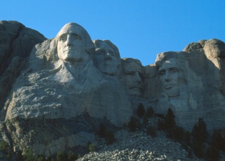
Mount Rushmore.
Fri 8 - We started a four day backpack that would center around Harney Peak, South Dakota's highest point. In the morning, to get some insight on likely water sources and good campsites, we stopped by the visitor center in Custer State Park to ask some questions. (Harney Peak is not quite in Custer SP, but it is very close, so that seemed like the place to inquire.) On asking about water sources, we were directed by the (non) helpful park employee to the water fountain in the corner. When we replied that we wanted to find water on the trail, as we would be out for three days, we received a shocked expression, as if the park employee had never heard of anyone being out that long! Needless to say, we got no useful advice there.
We started at the Willow Creek trailhead, just south of 244, and continued south along the Lost Cabin Trail, which eventually turned east towards a ridgeline where it intersected the Sylvan Lake Trail. We hoped to camp soon after this point, but as we continued on the short section south along the Sylvan Lake Trail, and then east along the Grizzly Bear Creek Trail, we did not spy any good campsites. We had met a hiker earlier in the day who said that there was a good campsite at the Grizzly Bear Creek Trail / Horse Thief Trail intersection, near a creek. With this knowledge, we kept moving, almost until dark, until this intersection, where we did indeed find a very nice campsite. By the time we had the tent set up and were cooking dinner, it was dark. Our planned 5 mile hike had become 8 miles, and we were very tired at the end!
Sat 9 - From our base camp, we hiked to the summit of Harney Peak, the highest point in South Dakota. From our camp, it was 3.7 miles, with 2200 feet of climbing, to the 7242 foot summit, which we reached around noon. On top of the peak is a lookout tower, originally built for spotting fires. Fittingly enough, it was in the process of burning down! The tower had a slow steady fire in some of the floor beams, and emitting smoke. Fortunately, it was soon put out with no significant damage to the tower. The view from the top was spectacular: Cathedral Spires and Little Devil's Tower were to our south, as we ate lunch on a rocky outcropping facing west. Four states were visible: Wyoming, Montana and Nebraska, as well as South Dakota. We then returned to camp, descending 600 feet to the Sylvan Lake Trail junction, 300 feet to the Grizzly Bear Creek Trail junction, and then another 1300 feet down to our campsite.
This same day, Mack Brown picked up his second (and so far, last) victory for Texas over Oklahoma, 38-28, en route to a high 20's national ranking that season.
Sun 10 - This day, we did a pretty strenuous loop hike south of our campsite. We started out southeast along the Grizzly Bear Creek Trail, to the intersection with the Centennial Trail, and then south. The Centennial Trail is a 111 mile long trail that passes through some pretty parts of South Dakota. We were to hike on several sections of this trail during this trip. The Centennial Trail markers have a longhorn symbol on them, and as we had not heard news of the football score, this gave us confidence that the Texas Longhorns had been victorious! After about a mile, we came to the Iron Creek Horse Camp, and then turned west along the Norbeck Trail, which followed Iron Creek for several miles, culminating in a steep climb to the Cathedral Spires Trail. A short jog northeast put us back on the Grizzly Bear Creek Trail, which we followed east back to our campsite. The wildlife 'highlight' of the day was a bee that stung Tom, after I had accidentally provoked it a bit.
Mon 11 - We packed up our camp, heading north on the Horse Thief Trail, passing not far from Mount Rushmore, to the Willow Creek Rushmore Trail, where we turned west and returned the Willow Creek trailhead where our car waited. On the way back to our motel in Rapid City, we stopped at the Crazy Horse monument, an under-construction monument similar to Mount Rushmore, that will depict Crazy Horse on his mount. These type of sculptures take a very long time to complete, and it won't be finished for many years! Back in Rapid City, we did some errands, and met a Nebraxa fan at the post office.
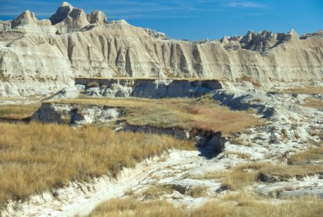
Tue 12 - We hiked a loop through the northern part of Wind Cave National Park, on several different trails including the Centennial once again. The terrain was mostly prairie grass on rolling hills, with a final bit on a road back to the car at the end. We passed by another prairie dog town, who's residents seemed to be particularly unafraid of people, and passed near a lone bison. We setup camp at the Elk Mountain campground, and then, just before sunset, drove a bit north to the short trail to the top of Rankin Ridge. The lookout tower along this trail is at the highest point in Wind Cave National Park. After admiring the sunset from the tower, we headed back to our campsite, where we enjoyed a hearty fire, hearty doses of Jack Daniels, and listened to elk bugle during the night.

Wind Cave National Park. The dark trees are the reason for the name Black
Hills.


The prairie dogs didn't seem very afraid of humans.

A hearty campfire, with elk bugling as a soundtrack.
Wed 13 - This day had us hiking a smaller loop in the park, one part along Beaver Creek, on the Centennial Trail once again, and the other leg on Lookout Point Trail. We saw a good sized bison herd along this walk, and also some reddish colored poison ivy. Also on this day (I think, it could have been the 12th) we took the short Garden of Eden tour of the cave, as well as the tiny nature trail that circles the campground. We then loaded the car, and headed west into Wyoming to Devil's Tower National Monument. As we drove towards our destination, we stopped briefly at an overlook, still miles from the tower. Another tourist who had stopped at the overlook did not seem very enthusiastic. After taking one look, he commented "Is there anything there? Well I've seen it... let's go" and he and his family continued on, apparently skipping a closer approach and much better look at the very interesting looking and impressive formation!
After we arrived at the park, we hiked the short 1.25 mile paved Tower Trail that circles Devil's Tower, as dusk approached. We saw a couple of climbers on the tower, and then moved on to set up camp, south of the tower with a fantastic view! That evening, I tried out my MRE. Tom had a freeze-dried backpacking meal for dinner, compared to my MRE. I thought my MRE was quite tasty, actually! (I did have one of the better flavors.) The main course is in a sealed pouch, and not freeze dried. That makes it a little heavier, but tastier. (The rectangular pouch doesn't, however, fit in my cooking pot all that well. The meal also came with a similar packet of applesauce, some high-calorie crackers, and even a small bottle of Tabasco sauce. Compared to freeze-dried, I definitely think an MRE is tastier.


Devils Tower seen from the Tower Trail.

A campsite with a view!
Thu 14 - We started with the 2.8 mile Red Beds Trail, which also circles the tower, farther out than the Tower Trail. It passes through some pretty red colored rock formations, and past some more prairie dogs. We had a combined lunch and rummy game, in the sun and wind, at a group picnic site. Late in the afternoon, we hiked the Joyner Ridge Trail, a 1.5 mile loop north of the tower (not encircling it, as the other trails did.) Along with some more distant views of Devil's Tower, with afternoon lighting, we saw some prayer flags. (Many Native Americans consider the tower as sacred.) As the sun set, we got back in the car and drove east, to Wall, South Dakota. Near the start of the drive, a deer ran out in front of the car. I had just hit a deer back in Austin, and when I considered the likely result of a collision at the 80 mph speed limit, I was not exactly reassured. Luckily, the drive was uneventful, and we arrived at a motel in Wall.

Red Beds Trail.
Fri 15 - Cold, windy and grey weather convinced us to hide indoors for part of the day. We started out with some breakfast at Wall Drug, a gigantic gift shop / museum / tourist trap, complete with fake dinosaurs along the highway, that got its start offering free ice water and 5 cent coffee to travelers in the Depression. Those two prices remain to this day, and we went through plenty of nickels for the coffee. We then headed to Badlands National Park. After setting up the tent at the campground, we checked out the Fossil Exhibit Trail (0.25 miles, and the fossils were all replicas) and also the Notch Trail, 1.5 miles, which went through some neat terrain and included a large ladder past a steep section. The cold weather made us retreat to Wall Drug where we spent some more nickels, before returning to camp for dinner.

Sat 16 - We set out for a three day backpack into the Sage Creek Unit of Badlands National Park. There are no maintained trails in this part of the park, but we had some good advice from a park ranger, and we set out southeast from the Sage Creek Primitive Campground. We partially followed the Middle Fork of Sage Creek, and partially followed bison trails, for 5 or 6 miles to the edge of a wall of badland, where we setup camp. As we explored the area around our campsite in the evening, a bison came by to remind us who was boss. Bison can be very dangerous, as they are really big, so we stayed away as it meandered around our camp, finally leaving us a big pile of bison poop.

Views from the road on the way in to Sage Creek.

Our sheltered campsite, although not from bison!
Sun 17 - Much improved weather, clear, warmer, and less windy, accompanied us as we explored the badland terrain around Hay Butte. The passages through the terrain can be extremely twisty, and we had a lot fun exploring. We ate lunch atop a long rectangular butte island below the southwest edge of Hay Butte, beneath a high stand of junipers on the hill to the south. Then we explored some box canyons and gulleys leading into the southern exposure of Hay Butte before working our way back out to the prairie expanse to the west, then trekking back north to our campsite.
Terrain around Hay Butte.
Mon 18 - We packed up our camp, retraced our steps to the car at the Sage Creek campground, and returned to Wall. We stopped again at Wall Drug, and took some time to check out the vast amount of stuff on display, as well as spending more nickels.

Views from the road on the way out of Sage Creek.
Tue 19 - Finally, we had to begin the return trip east to Chicago so I could fly back to Austin. This day, we made it near to Madison, Wisconsin (after passing though Austin, Minnesota, nearly astride I-35 as is Austin, Texas, further south). A short trip to a grocery store provided us with a variety of Wisconsinian beer, which we enjoyed as we watched the Braves eliminate the Mets on the hotel TV.

Wisconsin is a fine beer state.
Wed 20 - We returned to O'Hare airport in Chicago, where we parted company, and then I flew back to Austin.
(Photos by Tom Buckley and Mark Kness)