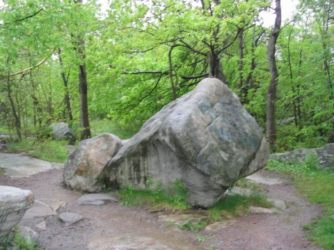
Summit boulder (unfortunately graffiti-marred) on Mount Davis.
Pennsylvania Highpoint - Mount Davis - 3213 ft
6 June 2005, 4:15 pm. Highpoint
#23.
Back to 2005 Northeast Highpoint Expedition
I started out following the Winger driving directions, from US 219 to Salisbury, then along SR 669 to 2002, and then along 2002 to the unpaved Christner Road. I turned right on Christner Road, and followed it for 1.7 miles. (So far, this matches the Winger directions). At this point, there is a marked intersection with another road (I think, South Wolf Rock Road). The Winger route continues north for 0.6 more miles, but instead I turned right and followed that road for 1.0 miles to the intersection with Shelter Rock Road, at around 2900 ft. Shelter Rock Road, an old road that is no longer used as such, is now a trail, with a gate to block any vehicle traffic. I parked in front of the gate, and gathered my stuff. The weather was poor - thunder and lightning was not far off, but since I expected to be in the trees most of the way, I decided to continue on. (This may not have been very bright.) I headed north, in steady rain, along Shelter Rock Road for about 2/3 of a mile, then turned left on Shelter Rock Trail which headed west and then north, to the summit, for a total one-way distance of around 1.7 miles. Once I got near the summit, the trees started to thin out, and I became more concerned by the lightning and thunder. I hurried along as fast as I could, balancing speed with the desire not to slip on the wet rocks! I was kind of confused with an intersection with the Mount Davis Trail. I figured it led to the highpoint, but it didn't seem to - I rejoined the Shelter Rock Trail before I reached the highpoint. Climbing the observation tower definitely seemed like a bad idea in the storm, so I just quickly scrambled up the summit boulder, took a few blurry pictures, turned around, and split.
Along the way, I got to see some Amish people as well. First, as I drove towards the trailhead, I followed some roads that I hoped would lead me to the Forest Foreman Headquarters. Instead, I got lost and passed some Amish farmers on some unnamed, unpaved road. They might not have appreciated my motor-car! Later, on the main roads, I passed a horse-buggy, and also some Amish women walking barefoot along the road.
I had originally planned to do a longer hike, with more elevation gain, than I did. My plan was to start along Tub Mill Run Trail, on South Wolf Rock Road (near the foreman headquarters) at 2500 ft, then join the High Point Trail to the summit. On the return, I would take Shelter Rock Trail to Shelter Rock Road, then take Timberslide Trail back to Tub Mill Run Trail, and that back to my intended start point. Due to lack of time (I still had Maryland to tag later that day) and the thunderstorms, I decided to do something shorter. Next time...
Summit boulder (unfortunately graffiti-marred) on Mount Davis.

Intersection of Christner Road with South Wolf Rock Road, with some nice yellow
flowers.
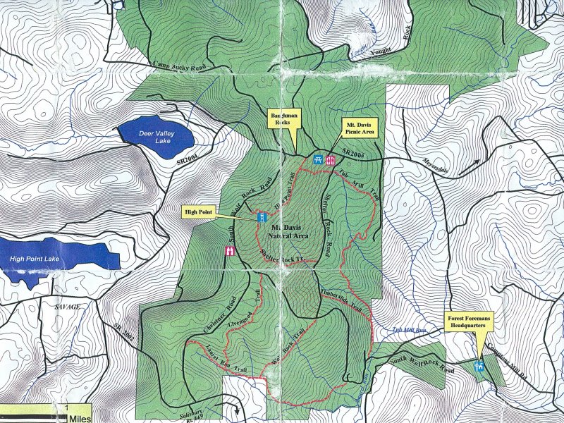
This map (a little the worse for wear) shows some of the trails in the area.
(Mt. Davis Area, Forbes State Forest, Pennsylvania Bureau of Forestry).
References
Highpoint Adventures, Charlie and Diane
Winger, Colorado Mountain Club Press, 2002.
Highpoints of the United States, Don W.
Holmes, University of Utah Press, 2000.
Mt. Davis Area Map, Forbes State Forest, Pennsylvania Bureau of Forestry.
I requested this map (partially reprinted above) by calling (724) 238-1200.
They will send you one that is not tattered like mine is now!
http://americasroof.com/pa.shtml