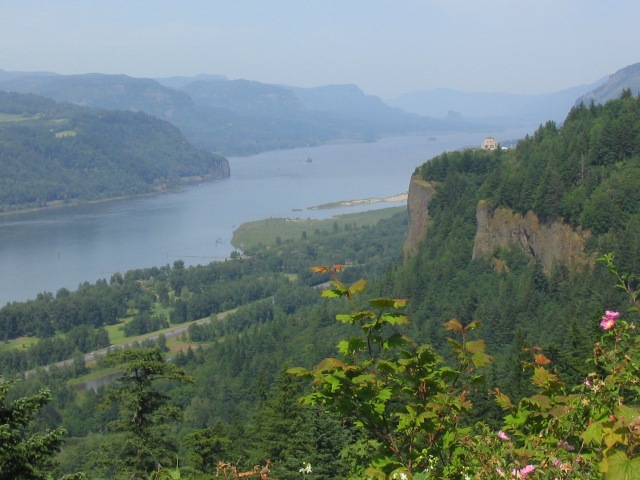
Looking east up the Gorge, from the Portland Women's Forum viewpoint. Vista House is visible on the bluff at the right.
Columbia River Gorge
2 Jun 2007
Back to Mount Hood
On Friday, after arriving at the Motel 6 in Troutdale and settling in, I took off in my rental car to check out the 'Historic Columbia River Highway'. Following the I-84 access road east from my motel, I found signs pointing towards the road, and as I crossed the Sandy River bridge, which is the 0.0 mile reference in my figures, I was off.
The geologic history of the Gorge is nothing short of awesome. Approximately 15,000 years ago, a 2000 foot tall wall of ice had formed a giant lake, Lake Missoula, in northern Idaho and western Montana. Suddenly, this dam broke, and a thousand foot deep torrent bore through the Columbia River drainage, carving it away. A number of other floods occurred in this general time period, which collectively gouged out the Gorge. The highway itself, which became known as the 'King of Roads', was constructed around 1915, soon after the advent of the mass-produced Model T. This was the first paved road in the Northwest, and is now the only road on the National Register of Historic Places. Heavy traffic now follows I-84, which is also actually a nice drive, but I thought the slow, winding, old highway would make a nice warm-up for Hood. At the 8.5 mile mark (east of the Sandy River bridge), just past Corbett, I came to the first nice stop, the Portland Women's Forum viewpoint. From there, one can see Vista House at Crown Point, and this was my second stop, at 9.9 miles, for some more nice views up the Gorge.
Looking east up the Gorge, from the Portland Women's Forum viewpoint.
Vista House is visible on the bluff at the right.

The Gorge from Vista House.
After Vista House, I continued east a few miles to Latourell Falls, and the parking area on the right at mile 12.0. My guidebook referred to a paved trail to the base, but I first found myself climbing a dirt trail heading towards the top of the falls. This trail didn't really open up to any extraordinary views of the waterfall, so I returned to the parking lot, and then found the trail to the base, which is at the right side of the parking area. This short (150 yard) trail led to the base of the waterfall, and this was a very nice spot. The rock is broken into interesting column-shaped pieces, which reminded me of Devil's Tower, the patches of different colors of green are pretty, and the sound and mist from the falling water complete the very aesthetic setting. Anybody driving along this road should definitely make this very easy hike, this turned out to be my favorite spot along the highway.

Latourell Falls, from a bit up on the ascending trail.

The base of Latourell Falls, accessed by a short paved trail, was a very pretty
spot.
The base of Latourell Falls. Don't miss this spot if you drive the
highway.
As I continued east from Latourell Falls, I missed my next planned stop, Bridal Veil Falls (15.0 miles), as the access was on the left (north) side of the road, while the other falls were on the right (south). So, I continued on to Wahkeena Falls, at 17.4 miles. Here, I found a paved trail, number 420, that switchbacked steadily up the side of the gorge, passing just in front of the falls at one point. The trail came to a marked viewpoint, with a nice view of the gorge. The trail continued further on, in fact, there seems to be quite a network of trails between the waterfalls along the gorge, and I only barely sampled them. This particular hike, I thought, would be a really nice place for a good workout. With the very good trail surface, steady climbing grade, nice views of the gorge, and occasional waterfall mist, this would be very nice for a run or a pack-carrying workout.

The trail passes just past the edge of Wahkeena Falls.

And then leads to a nice view of the Gorge. The trail continues on from
here, but I went back down at this point.
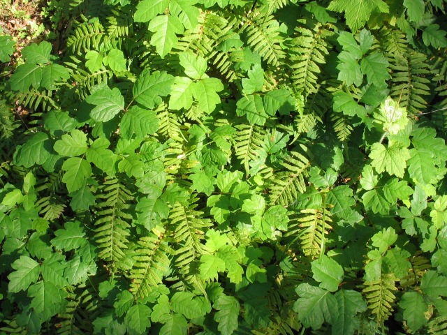
I had heard reports that there was a lot of poison oak around, this is one of
the few batches of it that I did see.
The next stop after Wahkeena Falls was Multanomah Falls, the largest and the most crowded and touristy of the lot. I just had time for the short walk to the bridge, but the trail supposedly continues to the to of the falls and perhaps onward.
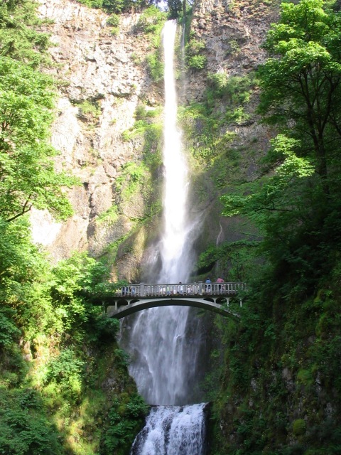
Multanomah Falls. This was the largest of the falls, and also the most
crowded and touristy. There is a trail heading to the top of the falls,
but I only took time for the short walk to the bridge.
After checking out Multanomah Falls, I turned back towards Portland. (The scenic highway does continue east for some distance, however.) First, I stopped at Bridal Veil Falls, finding the correct parking area, now on the right (south). A short, about 2/3 mile each way, trail headed to the base of the falls. Although these also were nice, I think I liked the other three waterfalls more than this one.

Bridal Veil Falls.
Then, I continued west, just 0.8 miles west of Vista House, to the turnoff for Larch Mountain, at 9.1 miles from the bridge. A 14 mile drive up the road led to the parking area for a couple of trails, which requested a $5 fee. I took the one that led to just below the summit of Larch Mountain, which had views of all the surrounding volcanoes. (Rainier, Adams, St. Helens, Hood, Jefferson). The sky was a little hazy, but I did get my first good look of the trip at Mount Hood. The sunset from here was supposed to be splendid, but I didn't want to stick around another two hours, as I had to get started early the next morning, for the climb itself, so I headed back to Troutdale to start packing.
This whole excursion only took me about 4 hours, and being so close to Portland I would certainly recommend it to others.

Mount Hood, from Larch Mountain.